
STB decision approved Thursday makes way for potential 457-mile cross-state trail loop, one of the largest in the world, to be built in Missouri over coming decades
Yesterday the Missouri’s Rock Island Trail took a major step forward–perhaps the biggest and most important step in this lengthy, complex process. The Surface Transportation Board approved the proposal by Ameren to transfer the rail line to Missouri State Parks to become a trail.
“As a Rock Island neighbor myself, I can tell you that this trail is going to be a major step forward for communities along the Rock Island line,” said said Brent Hugh, Executive Director of the Missouri Bicycle and Pedestrian Federation.
“The rail line has been nothing but trouble for the communities it runs through since rail traffic stopped more than 30 years ago. Now that sore spot will become an important amenity for communities that everyone can enjoy.”
The STB’s Thursday decision is a major milestone in the decades-long work to convert the long-disused, 217 mile long rail corridor into a statewide trail that will benefit all communities along the route.
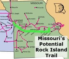
Map of Rock Island Trail. Thursday’s decision affects the portion of the Rock Island Trail between Windsor and Beaufort, plus a small section near Pleasant Hill.
The decision is to allow 145 miles of the line–from Windsor to Beaufort–to be removed from rail use, “railbanked”, and transferred to Missouri State Parks for use as the Rock Island Trail. State Parks and Ameren now have 90 days to complete a trail use agreement and forward it to the STB for approval. The State Parks and Ameren now have 90 days to complete a trail use agreement and forward it to the STB for approval.
“We are very pleased that Ameren, Missouri State Parks, and communities along the Rock Island line have been able to work together to come to this point,” said Hugh.
“The Rock Island Trail has the potential to be a major tourist attraction for the region, and a benefit to the communities it passes through.”
What does the future Rock Island Trail network look like?
• 143.7 miles – Rock Island, Windsor to Beaufort (near Washington) (State Parks). This is the segment the STB approved railbanking today.
• 47.6 miles – Rock Island, Pleasant Hill to Windsor – result of the Taum Sauk settlement with Ameren (State Parks). This segment was railbanked earlier this year and salvage work/trail construction is currenctly underway. There is another small segment of trail about 0.6 miles, through and near Pleasant Hill.
• 24.8 miles – Rock Island, Pleasant Hill to KC, currently in negotiations for purchase from Union Pacific (local municipalities). Jackson County Executive Mike Sanders announced a preliminary deal to purchase this segment earlier this year and he recently announced that work is progressing to finalize the deal. Perhaps the momentum of the new 144-mile addition to the eastern end of the Rock Island Trail will provide momentum to finalize negotiatios on the western end as well. This is 24.8 miles per this STB docket.
• TOTAL Rock Island Trail mileage Kansas City to Beaufort, is 216.7 miles
• The Katy Trail is now 240 miles (per the Missouri DNR) so total Katy/Rock Island system will be 457 miles


